


Today was going to be a different kind of hiking adventure for me. The plan was to hike in on the Signal Ridge Trail to the Carrigain Notch Trail and then bushwhack straight up through the woods to the summit of Vose Spur. This summit is a subpeak of Mount Carrigain and on the list of the New England Hundred Highest (NEHH). It is a trailless hike to a wooded summit with no views. Sunshine and cool temps were in the forecast.

Sunrise on the drive to the trailhead

Signal Ridge Trail

I would be joining fellow hikers Jill, Allison and Robin on this bushwhack to the summit of Vose Spur. They are all very experienced hikers having already completed both the New Hampshire 48 4,000 Footers and the New England 67 4,000 Footers lists. All three of them are also very close to completing the New England Hundred Highest that includes numerous bushwhacks to trailless summits that are required to complete the list. I was in very good company for my first bushwhack!

Veering right on the Carrigain Notch Trail

A leafy trail

Dry brook full of autumn leaves

More leaf scuffling

At the bushwhack rock

Another two miles and we came upon a large prominent rock surrounded by smaller rocks embedded in the ground. Just beyond here was the jumping off spot where the bushwhack would begin. Around the bend in the trail was a birch tree log on the ground on the left side of the trail. Having never been on a bushwhack before I was expecting that there might be at least some hint of a path from other hikers as this was on the NEHH list of hikes. There was nothing, we just stepped off the main trail, over the birch log and into the woods to begin our bushwhack.

Emerging from the woods onto the talus field

Looking up the talus field

Robin and Jill in a strategy session while Allison takes photos

View from the talus field


The climb got steeper and more difficult. We kept working our way up and to the west. I thought this might be the steep section that I had read about but it wasn't, that was still ahead of us. We were looking for a talus field that we needed to cross in order to stay on track. The climb continued to get steeper and brought us up over some short ledges. We found what appeared to be a faint herd path and followed it. This path eventually brought us to the bottom of the talus field we were looking for. I could see some cairns through the opening in the woods. It was a great relief to have made it to this point on our way to the top.

Signal Ridge

Allison, Robin and Jill enjoying the view

The walk across the rocks was very tricky as every one of them wobbled with each step. We stopped for a brief break and took in the beautiful views. The sunshine felt warm and the rocks were warmed by the sun so I sat there for a moment and absorbed some of that warmth. A short diagonal walk across and up the talus field and there was an opening into the woods. This time there was somewhat of a path to follow.

Moving up the talus field


Straight up!

Vose Spur summit cannister
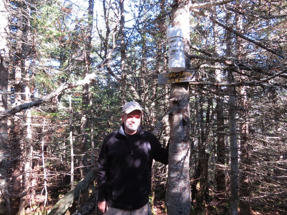
On top of my first bushwhack

One more bushwhack for Jill, Allison and Robin

Relaxing in the summit chair

Vose Spur summit pose

Steep descent

Controlled descent

Allison and Jill relax on the talus field

I was starting to think that we had missed the talus field. We took a more easterly track as we made our way down. As we kept moving to our left I saw what I thought was a clearing. Sure enough it was the talus field. We came out just below the cairns. A great feeling once again to have found the talus field as this is an important landmark that ensures we're on the correct track. Had we kept moving down and not moving to the left on an easterly track we would have missed it.


Carefully descending the loose talus field

Once out on the talus field we took our third break of the day. There was still more steep bushwhacking ahead of us and we soon continued our descent. At some point along the way I ended up in the lead again. I knew all we had to do was keep going down and we would eventually come to the Carrigain Notch Trail. As we got closer to the bottom of the notch there was a drainage route that I was following. When the terrain leveled out at the bottom of the notch I found that we were coming back out onto the Carrigain Notch Trail at exactly the same spot that we had entered. It was an awesome team effort with an impressive display of navigational skills that got us to the summit and back down again.

Descending on some more steep terrain


We saw a few hikers on the main trails during the hike in and out but there were no others to be seen during our bushwhack to the summit. Back on the main trail we set a quick pace back to the trailhead parking area and it was 4:23 when we arrived, seven hours and twenty minutes from when we started. The hiking time from other trail reports on this hike averaged seven hours. With three breaks we were well within this average time.

Back at the bushwhack rock

Seven hours and twenty minutes later we return to the trailhead
Having Fun in the Great Outdoors!
Another great read☺️
ReplyDeleteRavenJean