

With a one day break in the foul weather that we've been having I decided to hike Mount Adams (5,799 ft.) and add this to my list of 4,000 footers. Today's hike would take me up the Valley Way trail across the Scar Trail and onto the Air Line Trail all the way to the summit. There were no showers in the forecast but the high peaks were in the clouds. I was hoping they would clear by the time I reached the summit.

Mount Madison and Mount Adams in the clouds

Valley Way trailhead


Indian Pipe

Mossy Scar Trail

Air Line Trail
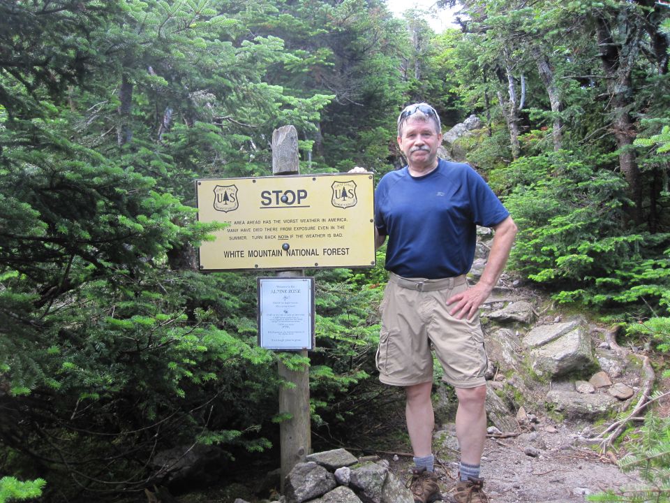
Warning!


First view of Mount Adams

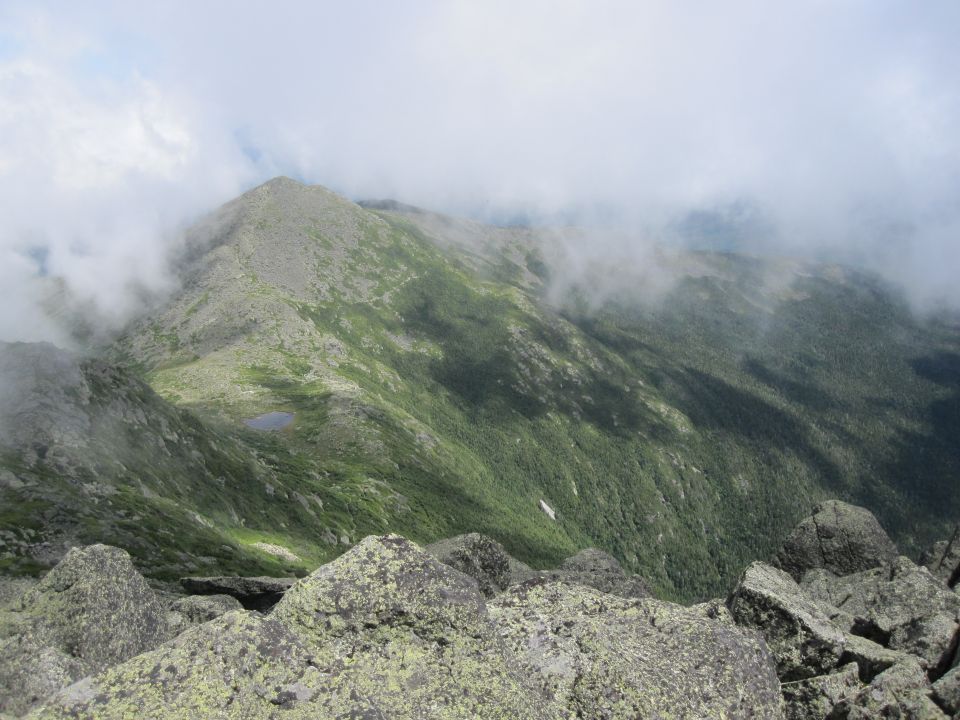
Clouds over King Ravine

This morning started off cool with a touch of humidity in the air. Within the first mile I was zipping off the legs on my hiking pants and it felt a lot better. It was quickly warming up. There were hikers behind me and hikers in front of me. I'm never quite sure when to pass someone but always sure when someone should pass me.


Standing on the edge of King Ravine

I reached the Scar Trail junction and veered right continuing on up to the Scar Loop. This was an interesting climb with a short section that required throwing my trekking poles ahead of me then belly crawling up over some steep ledge. There would be no second chances with a slip here! I passed a few open views before rejoining the main Scar Trail. This was a pleasant hike through a mossy forest with lots of Indian Pipe, a very unusual looking plant that has no chlorophyll and is ghostly white. I saw no other hikers on this trail.


A view into King Ravine


Scar Trail brought me over to Air Line and this would be my path to the summit. After passing through forest I was soon into scrub. There are spectacular views above treeline on this trail. I found myself frequently stopping to capture the scenic vistas with my camera as I passed over Durand Ridge. Clouds were moving up and out of King Ravine and passing over the summits.


Passing by the upper edge of King Ravine begins the last stretch to the summit. There are cairns and blazes but it is a rock hop to the top, a boulder field with no well-beaten path. There are places where you basically pick the route that's best for you.


Boulder field to the summit

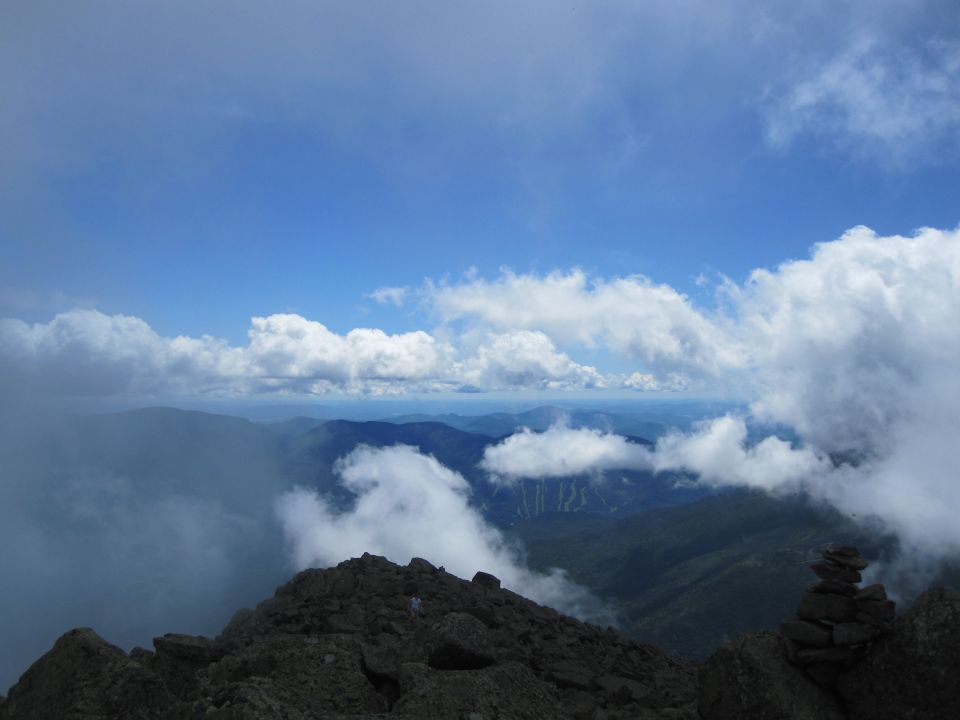
Reaching the summit is breath-taking. Clouds were continually brushing the peaks. Amazing views were seen in every direction. The breeze was minimal and it was nice and cool. This brought out multiple species of bugs and they all wanted to get up close and personal with me. After some photos and a snack I started my descent.

Last scramble to the top

A glimpse of Mount Washington

On the summit of Mount Adams
Mount Madison and Star Lake

Jefferson Ravine

I decided to use the Star Lake Trail down to Madison Hut. This is a steep descent with plenty of rock-hopping. After an initial rough climb down it levels out at the bottom and passes by Star Lake with the hut on the other side just below Mount Madison.


Madison Gulf

Looking back at Mount Adams summit from Star Lake trail


Getting closer to Star Lake

Mount Adams


My final descent to the Appalachia parking lot would be via the Valley Way. I found this trail to be very wet and very slippery. At one point I slipped and went down hard with my leg bending back underneath me. It caused a mild calf muscle strain but I jumped back up and kept going.

Sunbathing butterfly


Mount Madison from Valley Way trail

As I reached the bottom I veered off onto the Fallsway trail. It was well worth the side trip. There was lots of water flowing from all the rain we've had and the waterfalls were looking very nice.


Back at the Appalachia parking lot, it was not only full but vehicles were parked along Route 2 as far as I could see in both directions. Not surprising considering what a beautiful day it was. Mount Adams was #17 on my quest to complete the 48 4,000 footers. The hike to this summit was awesome with interesting trails and amazing views.
Summit view from Mount Adams
Having Fun in the Great Outdoors!
Great pictures! I just missed you on Adams, I hiked it the next day, Airline trail all the way up. Awesome mountain and views of Washington, I think, rival the views from Jefferson. Enjoyed the read on your experience.
ReplyDeleteThanks for your comment Joshua! I thoroughly enjoyed this hike and the fantastic views along the Air Line Trail as well as down the other side on the Star Lake Trail to Madison Hut!
Delete