

A great weather forecast for this weekend although calling for colder and windy on Sunday. Today I would be joining Brian and Jill for a hike across the Moat mountains. This includes North Moat (3,196'), Middle Moat (2,805') and South Moat (2,749'). For those that don't know, these are the mountains that are seen to the west when traveling through North Conway, NH. We would be hiking the Moat Mountain Trail from North to South for a 9.6 miles traverse.

Mount Washington on the drive to the trailhead

The adventure starts here

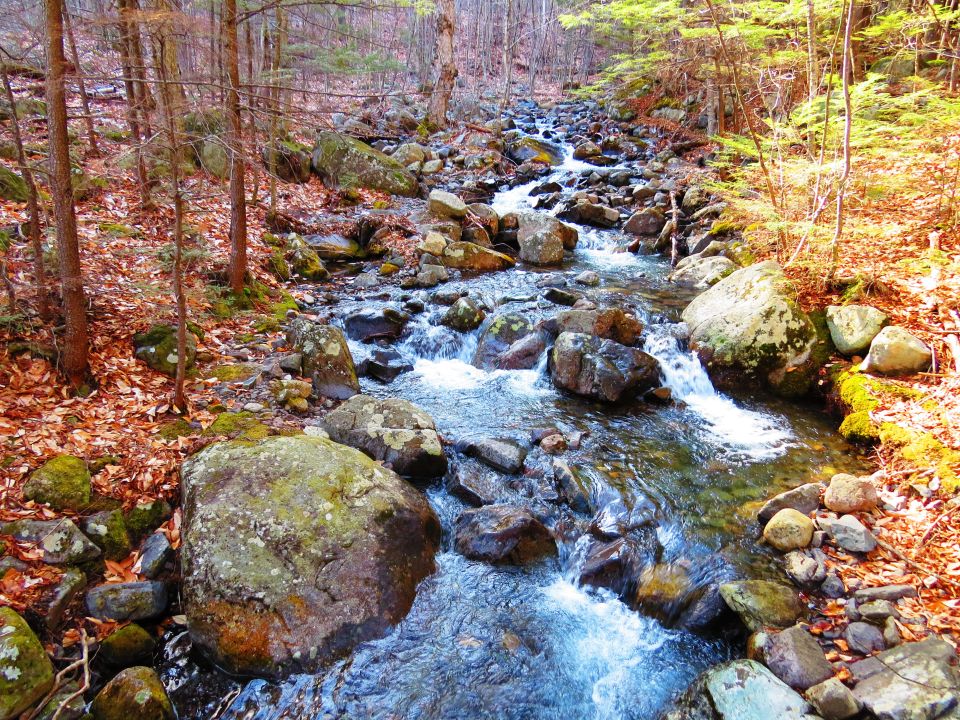
The waterfalls at Diana's baths


Bridged water crossing

Jill crosses without any problem
After checking the morning weather reports I was still not sure what to wear. A quick step outside in the dark let me know that it would be winter layers to start. I began my drive to the trailhead before sunrise. As I drove through Pinkham Notch the sun lit up the high summits, it was a beautiful early morning drive. This was the day of the Tuckerman Inferno and they were setting up for the race.

Brian easily crosses


Red Ridge Trail water crossing but we're not hiking that today

Jill's log crossing technique

Brian's log crossing technique

Some trail ice

I pulled into the trailhead parking lot for the south end of the Moat Mountain Trail. I saw two turkeys walking through the woods, a hen with a tom following close behind was fanning his feathers. The hen paid no attention. We planned to meet at 8:00 am, Jill and Brian arrived shortly after me. They put their gear in my car and I drove to the northern Moat Mountain trailhead.


A view of Mount Washington from the Moat Mountain Trail

Icy ledges begin

More ice

Dry ledges

We arrived at an empty parking lot, layered up on this cold morning and wasted no time getting onto the trail. It was a brisk walk to Diana's Baths and there was a good water flow coming over the falls. We stopped for photos and then continued on running into a preview of trail ice. The ice was easy to manuever over and around so we barebooted for now.

More icy ledges

Brian carefully placing his feet as he moves up the ice

Jill and Brian move cautiously on a steep section of ice


More steep ice to get up and over

Dry ledges to the summit of North Moat Mountain

Brian stops for a photo
There were a couple of water crossings we had to deal with. After a minor crossing with a makeshift bridge of small downed trees the second one required the help of some large downed trees and a good balancing act. I crossed first on a rather large but awkward tree that had me walking on a raised, narrow edge toward the middle. Jill chose another tree and butt slid across. Brian found another tree and walked across with no problem. We all arrived on the other side with dry feet.

On the summit of North Moat Mountain

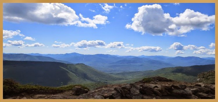
Western view

Northern view

Summit marker on North Moat Mountain

A view to the west

Ski trail on Attitash

South Moat in the distance
The trail followed Lucy Brook with beautiful waterfalls along the way. There were ocassional stretches of trail ice followed by bare ground. We reached the trail junction, Attitash Trail went straight ahead and we turned to start our climb up North Moat Mountain. The trail continued bare leading us to think maybe we had left the ice behind. As we climbed higher that would not be the case.

Kancamagus Highway far below

Brian and Jill posing

Mount Chocorua in the distance

Zooming in on the summit of Mount Chocorua

Mount Kearsarge North to the left and Mount Cranmore to the right

South Moat Mountain

Brian working his way down a slippery ledge


Vertical icy section of trail requiring a bushwhack

Brian deep in the bushwhack

Looking back up the trail after bushwhacking around this section

A view from the trail

Brian and Jill "sliding" down the ledge
There were areas of very steep and difficult ice requiring the assistance of trees and limbs for pulling ourselves up. This on and off traction routine continued until we reached the dry upper ledges just before the summit. Along the way we were treated to some great views. Once up on the summit we enjoyed spectacular 360° views. A quick check of my watch surprised me as to how much time it took us to reach this point of our hike, it was a very slow go up till now. There was a cold wind blowing so we got our fair share of photos then moved down off the summit.


Red Ridge Trail junction

Red Ridge Trail junction with North Moat and Washington in the distance


North Moat Mountain

Presidential summits in the clouds
Moving down into the trees brought us out of the wind. There were some more challenges along the way with a couple of very steep, icy drops. The first one we managed with a little help from the trees. The second one was a twenty foot vertical drop with some icy foot and handholds thrown in as an added bonus. We all agreed to bushwhack around this ledge. The bushwhack was not easy with us having to make our way through thick growth but it was a lot safer.

Almost to the summit of Middle Moat Mountain


Mount Chocorua

On the summit of Middle Moat Mountain

On the way to South Moat Mountain
Along the way between summits we stopped on a sunny ledge for a quick lunch. We then dropped down into a col where there was more ice, it would be the last time we used our microspikes. As the trail came up onto Middle Moat the ice was gone. We stopped long enough for a few photos then continued on to our final summit of the day. The trail got much easier from here with no ice and a moderate grade to the summit of South Moat Mountain.

Mount Washington Valley


White Horse Ledge below and Cathedral Ledge behind to the left


Once again we stopped briefly on the summit for photos. Other hikers that were there told us that we would not need the microspikes on the descent and I packed them away. I also took off my windbreaker in preparation for the trip down to the parking lot, the final 2.7 miles. There was an initial section of ledges then a stretch of trail with loose rocks and finally a nice smooth trail toward the end for a pleasant end to our hike. The North-South traverse was a strategic decision recommended by Jill to avoid ending our hike with icy, steep trails and water crossings. Better to get those obstacles out of the way at the beginning of a hike.

Descending South Moat Mountain

Brian descends the last ledge

Water cascades over a ledge

A very nice section of trail at the end of the hike

Final water crossing...bridged
I've hiked to South and Middle Moat Mountains a couple of times but had never done the full traverse. Although not a particularly difficult hike the ice factor created quite a challenge. We got a full body workout with having to pull ourselves up and down over slippery ledges. All of us took our turns falling down on the slick trail at various points along the way but luckily only minor bumps and bruises. It was a long day with some potentially hazardous conditions and we met very few hikers along the way so it was good to be able to hike along with Brian and Jill. With a sunny day, cool temps, interesting ice and three summits this hike turned out to be a great adventure!
Having Fun in the Great Outdoors!
What a great hike!!! Beautiful scenery!! I'm glad you arrived home safely😀
ReplyDeleteThanks!!
Delete