

With hot temps forecast for today I was looking for a 4,000 footer with some shade, Galehead Mountain seemed like a great choice. I was up early and on my way to the trailhead at sunrise. I drove up out of the valley where I live into a clear blue sky.

Up with the sun

Clear blue sky over the Presidentials

Trailhead

Turning off of Route 3 onto the dirt road at Five Corners I got a little confused when there was a fork in the road. The directions are in the AMC Guide and it states bear left then a sharp right which I didn't remember but did just that and got to the trailhead parking area without any problem. There was still some available parking spots early in the morning and I was soon on my way up the trail.

North Branch of the Gale River


Fresh moose track on the trail

It's a gradual climb with some easy water crossings, at least today they were. But I could see some problems in high water after a heavy rain. The trail has actually been rerouted after a storm in 2005 washed out some bridges. There is actually a sign posted describing this and I took a picture that describes the details.

Trail rerouted

Ball o' moss


Garfield Ridge Trail junction
In the first four miles before the Garfield Ridge Trail junction I met one other hiker coming down. I was also following fresh moose tracks and kept a watchful eye on my surroundings. It was nice and cool on the trail and I made the junction in just under two hours. I started meeting other hikers from here to the Galehead Hut.


Galehead Mountain

Twinway and Frost Trail junction


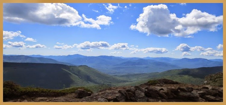
The Galehead Mountain summit has a small cairn, no views and lots of black flies, I didn't stay long. On my descent I stopped at a marked outlook with beautiful views but also had plenty of black flies. I stayed long enough to get a few pics and went back down to the Galehead Hut.

Galehead Hut


At the hut I had something to eat, rested for a few minutes and continued my hike of 4.6 miles back to the trailhead parking lot. The temperature was getting warmer and I was glad to be heading back down into the cool forest below.

Touching the Galehead summit cairn


A long drop behind me
I stopped and talked with a couple of ladies on their way up the trail that had come from Portsmouth (my hometown) this morning. One was going to "touch" South Twin for #48 to complete her 4,000 footers. I've been on several hikes where I met people doing their #48, it always gives me encouragement to complete my 48. I congratulated her and we continued on our separate ways.

Looking down on Galehead Hut

Galehead Hut zoomed

Common Wood Sorrel
Back at the trailhead parking lot I was approached by a hiker needing a ride along with her hiking companions to the Liberty Spring trailhead parking lot. There was a group of four and they looked hot and tired and I was glad to help out. We all squeezed into my Highlander and were on our way. I wasn't exactly sure where this trailhead parking area was so it was nice to be able to drive them there for future reference when I hike Mount Liberty and Mount Flume.


A last view from Galehead Mountain
Galehead Mountain (4,024') was #31 on my completed list of 4,000 footers. I'm not a fan of hot weather and thought the heat might slow me down but I completed the round-trip hike in 5 hours and 45 minutes. It was the perfect hike for a hot day!
A view from Galehead Hut
A view from Galhead Mountain outlook
Having Fun in the Great Outdoors!
No comments:
Post a Comment