After getting the latest weather forecast this morning I chose a hike that would be somewhat potected from a constant beating from the expected wind. Starting from the Pinkham Notch parking area I would use the Lost Pond Trail to Wildcat Ridge Trail. My destination was the Wildcat D peak, a 4,000 footer. The return trip would take me down the Wildcat Polecat ski trail and back to the Pinkham Notch parking, that was the plan. The plan would change.
A beautiful morning in Pinkham Notch
The beginning...
A view north on Lost Pond Trail
Lost Pond...found
There was a stiff breeze blowing, it was nice and cool in the forest on my way to Lost Pond. It's one mile to the Wildcat Ridge trail junction. Just on the other side of Lost Pond the trail becomes confused or maybe it was me. I've been here before and the trail just seems to disappear among some large boulders. I finally got back on the beaten path. So I found Lost Pond and the lost trail.
Lost Pond
Wildcat Ridge Trail junction
A light in the forest
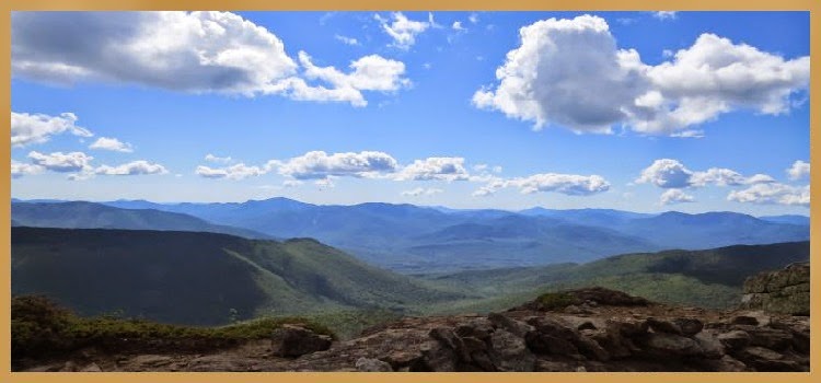
A view south from Wildcat Ridge Trail
Looking down at Route 16
There were two hikers at the Wildcat Ridge Trail junction. They had been just ahead of me. One of them had veered off the Lost Pond trail as I had so I guess it wasn't just me that had a problem whith that part of the trail. These two hikers were on their way up the Wildcat Ridge Trail to Carter Notch, 19 Mile Brook Trail and back to Route 16 where they had spotted a car at the trailhead there.
Mount Washington under clear blue sky
Another hike, another snake
I dropped down to the Ellis River to see how much water was flowing and the two hikers commenced their ascent. The Ellis River was low enough to rock-hop across. I turned around and started up the Wildcat Ridge Trail. It being bike week the roar of heavy metal thunder was heard during my entire hike.
View south from Wildcat Ridge Trail
William...aka Saber - Appalachian Trail Thru-Hiker
The perfect ledge for a break
Convenient steps on ledge
Low Bush Blueberry
It didn't take long before there was some serious up, and there was very little letup. This trail is not for the faint of heart or those that are afraid of heights. There are a few spots that you want to make sure your shoelaces are tied. This is no place for a misstep. A fall off the side of the ledges would definitely make a bruise...or worse!
More steps in just the right place
Mount Adams and Madison
Tuckerman Ravine still has some snow
Ledge steps
Up past the ledges there is an outlook with views to the south. This was a great spot for a break before tackling the next ledges up ahead. It is here that I met a hiker named William, originally from Guyana. He recently retired from the Army as an infantry scout and was hiking the entire length of the Appalachain Trail. Saber (trail name) started his hike in Georgia at the beginning of March and he expected to reach Mount Katahdin at the end of June. He said he was averaging 30 miles a day. I would see him a couple of more times between here and the summit.
Tuckerman and Huntington Ravines
The view from the back of Wildcat
The trail levels out a little before reaching the next set of ledges. It was here on an exposed ledge with a nice breeze and view that I met up again with the two hikers I met earlier as well as Saber. We all talked for a few minutes and then it was time to complete the final stretch to the summit. It was at the top of Wildcat that I would see Saber one more time.
Where I just came from
Dead man's curve far below
Pinkham Notch looking north
It was on the summit that I realized my hiking plan would change. All trails from the top of Wildcat were closed and there would be no hiking down the Polecat trail as planned. I had actually read this a couple of weeks ago but thought they were open again but they're closed until June 21st. There are ropes across the trails and threatening signs posted warning of severe penalties for anyone caught on the upper part of the ski trails.
Labrador Tea
Vertical trail
Not a place to step off the trail...it's a long way down through thin air!
Well, I had one choice, hike back down the way I came up. After accepting this I went up to the observation tower and enjoyed the views of the Presidential Range. White, puffy clouds were starting to roll in but never covered the summits. I stayed for a few moments then it was time to start my descent.
A nice cool spot on the Ellis River
Ellis River trail crossing
The home stretch
There were several hikers ascending as I was descending. Almost all of them told me the same thing, "it's steep!" I already knew that, it was just as steep going down as it was going up. The only difference was it required less rest stops and of course it took less time.
A very big woodpecker has been here!
...the end of today's hike
Birdsfoot trefoil
One last look at today's hike
Down at the bottom I decided to cross the Ellis River and use the Direttissima trail to return to the Pinkham Notch parking area. This would be the last mile of today's hike. It would have been nice to have done a Wildcat traverse but without spotting a vehicle at the other end it becomes problematic. I'll be back another day to hike Wildcat A from the Nineteen Mile Brook Trail. The hike to Wildcat D today was #14 on my list of 4,000 footers.
Having Fun in the Great Outdoors!


No comments:
Post a Comment