


The weather forecast was perfect for a climb to the summit of Mount Washington (6,288'). This was #12 on our list to hike the 48 4,000 footers. It was a cold morning and we left before the sun was up. Arriving at the Cog Railway Marshfield Station hiker parking lot found the sun still behind the mountains and five vehicles already there. We put on some layers, strapped on our packs and were on our way to the top!


The Jewell Trail is located just across the tracks past the train where passengers board. After crossing a bridge the trail rises slightly and it appears part of the trail has been rerouted. We walked over some very icy plank bridges through a small frozen boggy area. The trail junction was reached and we turned right to start our ascent on the main part of the trail.


The grade was moderate through the woods up to treeline. There was spotty snow and ice but we bare-booted the entire hike. Beyond treeline the trail was rocky and somewhat steeper. We met our first two hikers along this part of the trail. They had slept in a col last night and told of the clear sky full of stars.


The trail climbed steadily up to the junction of the Gulfside Trail. We turned right at the junction and made our way toward the summit of Mount Washington. There was no snow or ice and it was a rock-hopping trek along this part of the trail.


At one point the trail hugged the top edge of the Great Gulf and one misstep would have been disastrous, okay - deadly. It was very nerve wracking and I kept my little hiking buddy within arms reach. It didn't seem to bother him at all.


We crossed the cog railway and continued on to the summit using the Crawford Path. There was a group of hikers that had ascended using the Ammonoosuc Ravine Trail, one of the hikers was a friend and co-worker. It was recommended that this trail not be used for descending. I had already planned to use the Jewell Trail for our descent having read the trail reports prior to this hike.


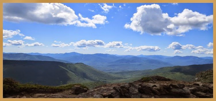
It was great to be on the summit! The views from the top were spectacular in every direction! The hike up took us 3.5 hours.


We got the customary photo taken at the summit sign. Then it was time for a well deserved break. I took some photos, we ate some lunch and relaxed for a bit enjoying the breath-taking scenery. I saw no more that 15 people the entire time we were on the summit.


Soon it was time to make our descent. We used the Trinity Heights Connector down to the Gulfside Trail and then walked on the service road beside the cog railway before turning right onto the Westside Trail meeting up with the Gulfside Trail again.


The rest of our descent was a return trip using the Jewell Trail again. It was a pleasant trek down and we reached the parking lot in 2.5 hours.


Today's hike up Mount Washington was as close to perfect as it gets. There was free parking at the cog, no bugs, no heat or humidity (but still sweat), cool, clear, no wind, lots of blue sky, no significant ice or snow on the trail, and no crowds...perfect!
Having Fun in the Great Outdoors!
South to East to Northeast Panoramic view
West to North to East Panoramic view
No comments:
Post a Comment