Rain showers last night gave way to clearing conditions this morning as a cold front pushed through. Clouds were quickly clearing creating a spectacular sunrise as I made my way to the trailhead. Today's hike would take me to the top of Mount Chocorua via the Champney Falls Trail. It was shaping up to be a beautiful day as I turned onto the Kancamagus Highway.
 |
| Spectacular Sunrise |
 |
| Pinkham Notch at Sunrise |
 |
| The beginning |
 |
Captured tree
The Champney Brook Trail is very popular and I was expecting to see a number of vehicles in the parking lot, there was one. The morning air was cool and the breeze felt good as I stepped into the forest. This would be a solo hike today. Probably a good time to mention that apparently at some point there has been a trail name change. The AMC Guide and my EMS White Mountains hiking trails map have this trail listed as Champney Falls Trail. All signs that I saw today have it as Champney Brook Trail. Time for them to update the maps.
|
 |
| Morning sun rays |
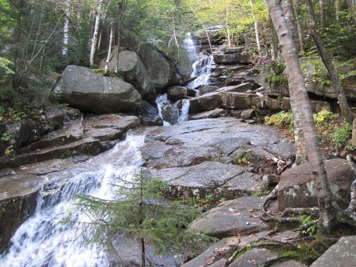
At 1.4 miles there is a side trail that passes beside the falls. It rises steeply but has stone steps in places to help with the ascent. After last night's rain the water was flowing nicely over these waterfalls. The trail takes a sharp right and at 0.4 mi. connects back to the main trail.
 |
| Splashing sunlight |
As I continued my ascent the trail became very wet with a steady trickle of water moving down the middle of the path. While caution was needed on wet rocks and roots the running water was easily navigated and posed no other problems. There was a portion of the trail that was slanted smooth ledge (and wet) that also required a degree of caution.
 |
| View from Piper Trail |
I came up to a clearing and a trail junction, the Three Sisters trail turned left. It was here in the sun that I decided to change to a dry shirt and windbreaker after doing a fair amount of sweating. There was a stiff wind blowing and the dry clothes felt good. The voices that I had been hearing caught up to me, it was a group of young people with young legs. They never slowed down and were soon out of sight until I saw them high up on the ledges.
 |
| Going up... |
 |
| ...up some more |
 |
Group of hikers on summit
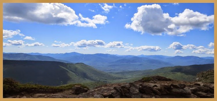
The next trail junction put me on the Piper Trail that would take me to the summit. There was another trail junction that provided a path to the summit in bad weather, I stayed on the fair weather trail (Piper Trail). Another 0.3 mi. and the ledge scramble began, it was nothing but granite for the rest of the way to the summit. I have to admit that I got sidetracked a few times and lost sight of the blazes, got myself back ontrack and continued up. The views were amazing and I knew there would be a real treat at the top.
|
 |
| West view |
 |
| South view |
After one final scramble I was on the top. It was a spectacular sight in all directions! I took plenty of photos, relaxed, and ate lunch. There was a cool breeze but the sun was warm. There were many people enjoying the panorama. I waited for the crowd to clear the summit then took a 360 degree movie shot. A steady stream of people were coming up the trail and I decided to head back down.
 |
| Southwest view |
 |
| Summit |
 |
| Chocorua Lake below |
 |
| East view |
I packed up my poles until I cleared the ledges, they were more of a hinderance than a help. After clearing the exposed granite I broke out the poles again. It was a quick trip back down, one hour and ten minutes to cover the 3.8 miles from summit to parking lot.
 |
| Going down... |
 |
| Chocorua peak in the distance from Bear Notch Road |
I arrived at the trailhead to find the parking lot full. One last photo and I was on my way home. It was an awesome hike to some spectacular views on an early Fall day!
Having Fun in the Great Outdoors!


No comments:
Post a Comment